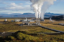
Krafla Geothermal Power

From the first exploratory drilling in 1974 to reaching full 60MW capacity in 1999, the Krafla geothermal power plant has had an interesting story.
For a while it was uncertain whether Krafla would ever actually enter operation when, early on, large-scale volcanic eruptions occurred only two kilometers away from the station, posing a serious threat to its existence. Work continued, however, and phase one of the power station went on line early in 1977.
Krafla Geothermal Power Station Timeline:
1974 - The first trial boreholes are drilled
1975 - Beginning of seismic and volcanic impacts threaten continued development of the plant
1975 - Sinking production wells and construction of power plant despite seismic activity
1977 - Power Plant begins operation
1978 - Plant begins power production
1984 - Significant decline in seismic and volcanic impacts
1996 - Installed 2nd steam turbine and beginning of additional drilling
1999 - Producing 60MW (planned capacity)
In total, 33 boreholes were drilled, including 17 high pressure production wells and 5 low-pressure production wells. The plant uses 110kg/second of 7.7 bar saturated high-pressure steam and 36 kg/sec of 2.2 bar saturated low-pressure steam and has been in operation at 60MW since 1999.
Mannvit's involvement in the Krafla geothermal power plant started in 1994 and lasted until 2002 and revolved mainly around the development of the second phase of the project.
Mannvit Services:
- Feasibility report
- Site lay-out planning
- Conceptual design
- Detailed mechanical design
- Environmental impact study and report
- Modeling of groundwater flow and transportation of contaminants
- Project management
- Overall plant design
- Detailed design of HVAC systems
- Bid preparation and tender evaluation
- Site supervision
- Commissioning
Svartsengi geothermal power plant

The Svartsengi Geothermal Power Plant is a geothermal power station located in Keflavik, Iceland, near the Keflavík International Airport at the Reykjanes Peninsula. As of December 2007, it produces 76.5 MW of energy, and about 475 litres/second of 90 °C (194 °F) hot water (ca. 80 MW). Surplus mineral rich water from the plant fills up the Blue Lagoon, a tourist bathing resort.
| Svartsengi Power Station | |
|---|---|
 The Blue Lagoon with the power station in the background. | |
| Location | Keflavik, 63°52′44″N 22°25′58″W / 63.87889°N 22.43278°WCoordinates: 63°52′44″N 22°25′58″W / 63.87889°N 22.43278°W |
| Owner | HS Orka |
| Status | Completed |
| Fuel | Geothermal |
| Installed capacity | 76.5 MW |
| Commissioned | 1976 |

Nesjavellir Geothermal Power Station

The Nesjavellir Geothermal Power Station is the second largest geothermal power plant in Iceland. The facility is located 177 m (581 ft) above sea level in the southwestern part of the country, near Thingvellir and the Hengill Volcano.
Plans for utilizing the Nesjavellir area for geothermal power and water heating began in 1947, when some boreholes were drilled to evaluate the area's potential for power generation. Research continued from 1965 to 1986. In 1987, the construction of the plant began, and the cornerstone was laid in May 1990. The station produces approximately 120MW of electrical power, and delivers around 1,800 litres (480 US gal) of hot water per second, servicing the hot water needs of the Greater Reykjavík Area.
| Nesjavellir Geothermal Power Station | |
|---|---|
 Nesjavellir Geothermal Power Station | |
| Location | Thingvellir, 64°6′29″N 21°15′23″W / 64.10806°N 21.25639°WCoordinates: 64°6′29″N 21°15′23″W / 64.10806°N 21.25639°W |
| Status | Completed |
| Fuel | Geothermal |
| Installed capacity | 120 MW |
| Commissioned | May 1990 |
Reykjanes Power Station

The pioneering Reykjanes Geothermal Power Plant in Iceland is now producing 100MWe from two 50MWe turbines. The plant uses steam from a reservoir at 290 to 320°C – the first time that geothermal steam of such high temperature has been used to generate electricity on a large scale.
The new plant is located on the Reykjanes peninsula, in the south-western corner of Iceland. Owned by Sudurnes Regional Heating Corporation, the plant was designed by Enex, a conglomerate from the Icelandic energy sector with wide experience in developing geothermal energy and hydropower. The two turbines started operation in May 2006 after testing and were formally brought on-line in December 2006.
HIGHEST TEMPERATURE YET FOR GEOTHERMAL STEAM
The Reykjanes plant uses steam and geothermal brine extracted from twelve 2,700m-deep wells. After extraction, the brine is piped into a steam separator. From there, the separated steam passes under 19 bars of pressure to a steam dryer and into the two 50MW turbines.
The plant is situated close to the ocean front, so seawater (4,000l/s) at 8°C can be pumped through a condenser for cooling and condensing the brine.
NEARLY 20% OF ICELAND'S ELECTRICITY FROM GEOTHERMAL
Geothermal resources have been used for over 70 years in Iceland. The geothermal area at Reykjanes is located on top of the Mid-Atlantic Ridge, formed by plate tectonics that are moving in separate directions. That gives high geothermal energy, with the Reykjanes area being where the plate boundary of the Reykjanes Ridge comes on land. The area is about 2km2 in size. Energy has been extracted from the area for around 30 years without significantly reducing the geothermal reserves.
Geothermal power plants produce nearly 20% of the country's electricity; geothermal heating also supplies nearly 90% of the country's domestic heating and hot water requirements. Nearly all the rest comes from hydroelectric generation, with less than 0.1% from fossil fuels.
Geothermal brine cannot be used directly for heating because of its high mineral content. On cooling, it releases great quantities of hard deposits (silica) which block pipes and other equipment. The high temperature and salt content of the water therefore demands heat exchangers.
| Reykjanes Power Station | |
|---|---|
 Reykjanes Power Station | |
| Location | Reykjanes, 63°49′35″N 22°40′55″W / 63.82639°N 22.68194°WCoordinates: 63°49′35″N 22°40′55″W / 63.82639°N 22.68194°W |
| Owner | SRHC |
| Status | Completed |
| Fuel | Geothermal |
| Technology | Steam turbine |
| Turbines | 2 |
| Installed capacity | 100 MW |
| Maximum capacity | 150 MW |
| Commissioned | May 2006 |